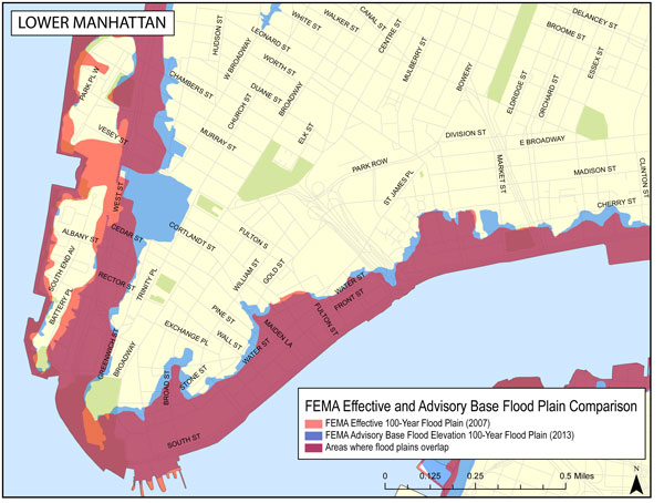
 Map of Lower Manhattan that New York City officials have prepared based on the latest information released by FEMA. The blue indicates areas that are proposed to be added to the flood zone, the orange indicates areas that are likely to be removed. Red areas would remain in the flood zone if the new map is approved.
BY JOSH ROGERS & TERESE LOEB KREUZER | Hey Battery Park City, it may get easier to get flood insurance, although you’ll still probably have to evacuate before the next storm.
The Federal Emergency Management Agency just released a preliminary map of Lower Manhattan placing almost the entire neighborhood out of the two highest risk areas for floods.
Some of the neighborhood was taken out of Flood Zone A, the second riskiest area.
The map is for insurance purposes only and does not relate to the city’s evacuation maps, which designate their own Zone A, an area that still includes all of Battery Park City and much of Lower Manhattan.
A spokesperson for the city’s Office of Emergency Management said the FEMA map will not affect the evacuation map.
Hannah Vick, a FEMA spokesperson, told Downtown Express that the agency has been preparing the flood elevation maps for awhile and “we didn’t want to sit on that data.”
The preliminary map is interactive and allows users to enter an address to find out of they are in a high insurance risk area.For those not in the highest risk area, Zone V, or in FEMA’s insurance Zone A, there “wouldn’t be any requirement to elevate or strengthen their home or structure,” Vick said.
In Lower Manhattan, the narrow Zone V, which stands for velocity, runs along the Hudson and East Rivers and also includes some of the area on West St. It does not appear to include any residential buildings in Lower Manhattan.
Beyond this flood zone, the maps show that large parts of Lower Manhattan are in insurance Flood Zone A, with a lesser, though still substantial, risk of flooding.
The A Zone has been extended to include all of the World Trade Center site and more of Downtown’s East Side, with a little more of the Seaport area, the Lower East Side and the East Village included.
A small part of Battery Park City — an area near Little West St. from the southern tip up to W. Thames St. remains in Zone A.
The previous map based on 1983 water elevations only put a tiny sliver of the W.T.C. in the flood zone, but the new map is unlikely to alter construction plans at the site since Port Authority and 9/11 Memorial officials have been insisting since Sandy that the vast underground area with the museum, transit hub and large mechanical equipment will be able to be sealed off before heavy storms.
In order to see the suggested changes visit here and on the left click on “National Flood Hazard Layer (Sandy Area)” to see the existing insurance map and “Advisory Base Flood Evacuation Layers” to see the proposed changes.
FEMA’s Vick said there will be a long consultation and appeals process before the map is finalized and it will ultimately be up to New York City to decide whether it wants to remain part of the National Flood Insurance Program.
At a briefing Feb. 26 with FEMA, Dep. Mayor Cas Holloway said it would take about two years to finalize the new map.
The new maps are based on studies that were already under way before Superstorm Sandy.
Until finalized maps are available, Advisory Base Flood Elevations can help communities, home and apartment owners and businesses better understand flood risks so that buildings can be modified and constructed to reflect the new reality. Buildings with reduced flood risk because they have been elevated or otherwise modified will have significantly lower insurance premiums.
The maps show the probability of a flood in any given year. Advisory Zone V could be flooded by high velocity, breaking waves of three feet or more. Buildings in this zone must be elevated over an open foundation so that waves can break under them.
In Zone A, flooding from storm surges can be expected. The lowest floors of buildings in this zone should be used for parking and building access, with utilities raised above the base floor elevation or otherwise flood-proofed.
Every flood zone on the FEMA maps has a base flood elevation (BFE) assigned to it which identifies the level to which flood-proofing is required by FEMA guidelines.
For each location, the guidelines describe a 1 percent chance of water rising above the coastal water surface elevation in any given year, and a 0.2 percent chance. The elevations that would be protective in the event of a flood are expressed in feet.
In the narrow part of Battery Park City, for instance, in Flood Zone V, structures would have to be elevated by 16 to 21 feet above sea level to be safe from anticipated flooding. In Flood Zone A, they would have to be 12 to 16 feet above sea level. The protective elevations vary from building to building and block to block.
Flood damage is not covered by most homeowners’ insurance policies however the federal government has set up a National Flood Insurance Program, which is available from private insurers, but which the federal government backs and supervises. This insurance can protect homes, businesses and belongings.
A home can be insured with NFIP for up to $250,000 for the building. Renters and homeowners can take out up to $100,000 worth of insurance on contents.
Up to a total of $1 million is available for non-residential buildings. This coverage would consist of $500,000 for the building and $500,000 for its contents.
There is usually a 30-day waiting period before coverage goes into effect.
Regardless of flood risk, most people can buy NFIP coverage if they live in a community that participates in the program. All five boroughs of New York City participate. Policies are available to homeowners, condo owners, apartment owners, renters and business owners.
However, according to Howard Slatkin, director of sustainability for the New York City Department of City Planning, “Premiums for many properties in New York City are expected to increase substantially until they reach market rate. Buildings that once had preferential rates because they were built before FEMA’s current flood elevation maps and were grandfathered in, will no longer be eligible for those rates. So if you’re constructing a building today, it’s important to use [the new] information in order to prevent being hit by increased flood insurance rates.”


