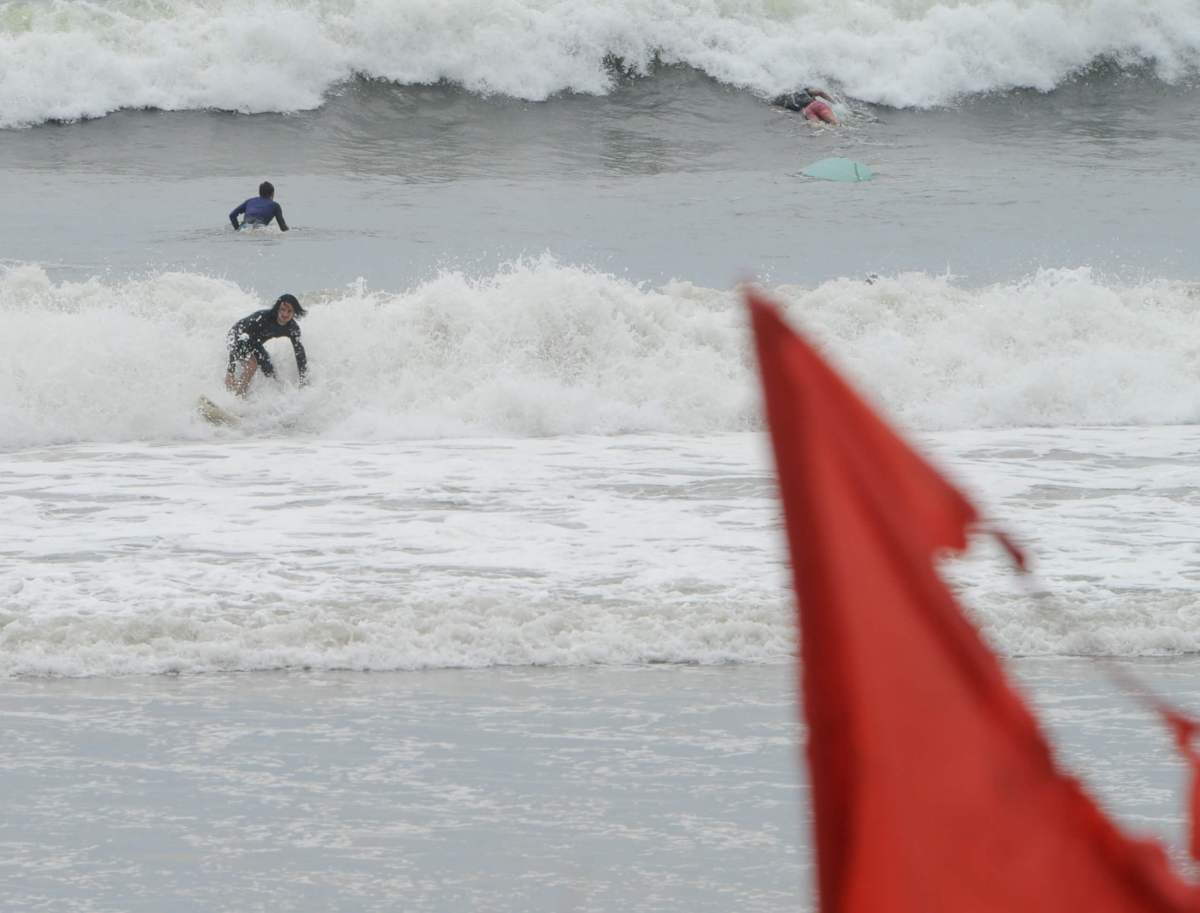
New York City is bracing for the onslaught of Hurricane Henri, which is expected to make landfall Sunday on eastern Long Island as the first hurricane to do so in 36 years.
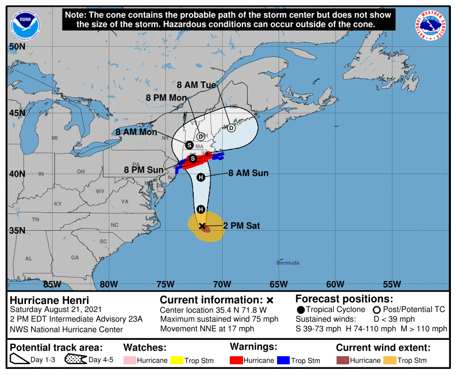
Henri strengthened into a Category 1 hurricane on Saturday as it continues its northern move up the Eastern Seaboard before 11 a.m. storm, and it seems to be picking up steam on its journey. Tropical storm force winds are expected to arrive early Sunday morning, and landfall on Long Island could happen on or about noon Aug. 22, based on the National Weather Service’s latest advisory.
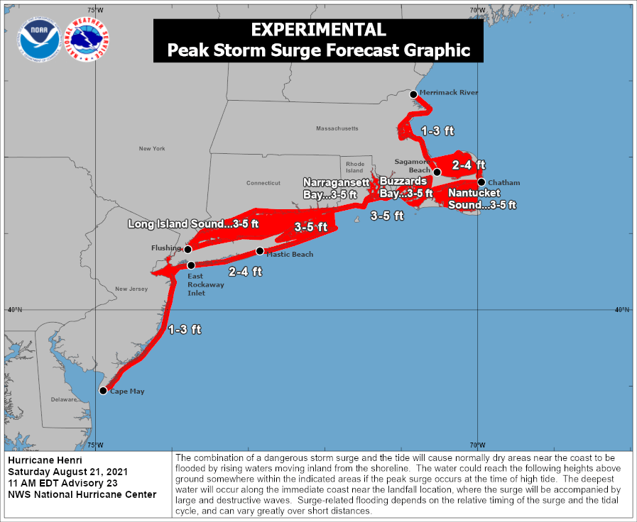
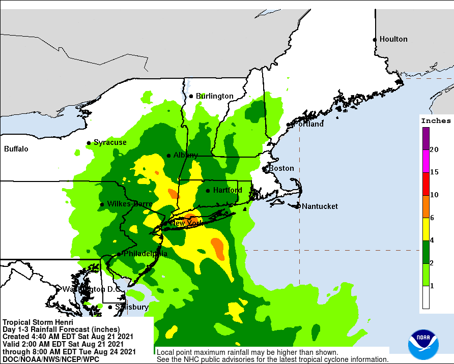
Suffolk County is under a hurricane warning, and New York City and Nassau County are under a tropical storm warning for the indirect impacts of Henri — namely heavy rain (3 to 6 inches possible across the region between Saturday night and Monday morning), strong winds and a potential for storm surge for shorelines along the Long Island Sound in northern Queens and the Bronx.
Thus far, the city hasn’t ordered evacuations for any coastal areas. The National Weather Service indicated Saturday that the storm surge would potentially cause major beach erosion and damage to marine infrastructure (dunes, piers, docks, boardwalks, etc.).
On Saturday afternoon, outgoing Governor Andrew Cuomo declared a state of emergency for Long Island, New York City, the Hudson Valley and Capitol District regions in anticipation of effects from Henri. He also asked President Joe Biden for a pre-landfall disaster declaration, and the president indicated his willingness to abide by that request.
“If you know you are in an area that tends to flood,” Cuomo advised residents in the path of Henri, “get out of that area now, please, and get to another and better place of safety.”
Lieutenant Governor Kathy Hochul — who will take office as New York’s 57th governor at midnight on Tuesday after Cuomo’s scheduled resignation Monday night — has been briefed on the state’s disaster prep efforts, Cuomo said.
New York City ordered all beaches closed Sunday and Monday, Aug. 22-23, because of the strong waves expected from Henri. The city’s Emergency Management Department advised residents to remain home Sunday due to the severe weather potential — or to take public transportation if they must travel tomorrow.
The TD Bank Five Borough Bike Tour, originally scheduled for Sunday, was postponed due to the impending storm, the NYPD announced. Outdoor dining and the city’s Open Streets program will also be suspended for Sunday, the city’s Department of Transportation announced. Restaurants with outdoor setups must move them off the street to a secure location.
Long Island in the crosshairs
As of 2 p.m. Aug. 21, Henri’s center of circulation sat about 395 miles south of Montauk Point, moving to the north-northeast at about 17 mph. It’s expected to rush up toward our area tonight, with the center of circulation sitting just to the south of Long Island by 8 a.m. Sunday morning. But forecasters believe the storm will begin to slow down as it crosses over Long Island, with the center of the system sitting over southeastern Connecticut at 8 p.m. tomorrow night.
It’s expected that Suffolk County will bear the brunt of the storm — with waves 3 to 5 feet higher than normal and between 8 and 10 inches of rainfall expected, Cuomo noted.
Long Island hasn’t received a direct hit from a hurricane since Gloria struck in 1985. The category 1 storm devastated the island’s power grid, and it took weeks for it to be restored; PSEG Long Island warned that it could take up to a week or longer to fully restore power if parts of Long Island suffered a similar hit from Henri.
“Given the potential intensity of the storm, the damage may be severe and some outages may last up to seven to 10 days; however, if the forecast continues to strengthen and the storm moves farther west, restoration could take up to 14 days,” said Michael Sullivan, senior director of Transmission & Distribution at PSEG Long Island, on Saturday. “We are prepared for hurricane force winds and are informing customers to help set expectations about the storm’s potential so that they can also prepare.”
Meanwhile, Suffolk County Executive Steve Bellone ordered a voluntary evacuation of Fire Island. All ferry service out of the summer haven will be suspended Sunday.
The Long Island Rail Road is suspending service east of Patchogue on the Montauk Branch, and east of Ronkonkoma on the Greenport Branch, at midnight Saturday, Cuomo added. The suspension will last through Sunday, according to the MTA.
The last westbound train on the Greenport Branch departs at 9:03 p.m. Saturday night; the last westbound trains on the Montauk Branch depart from Montauk at 7:37 p.m. and from Speonk at 11:57 p.m. Saturday evening.
NYC impacts
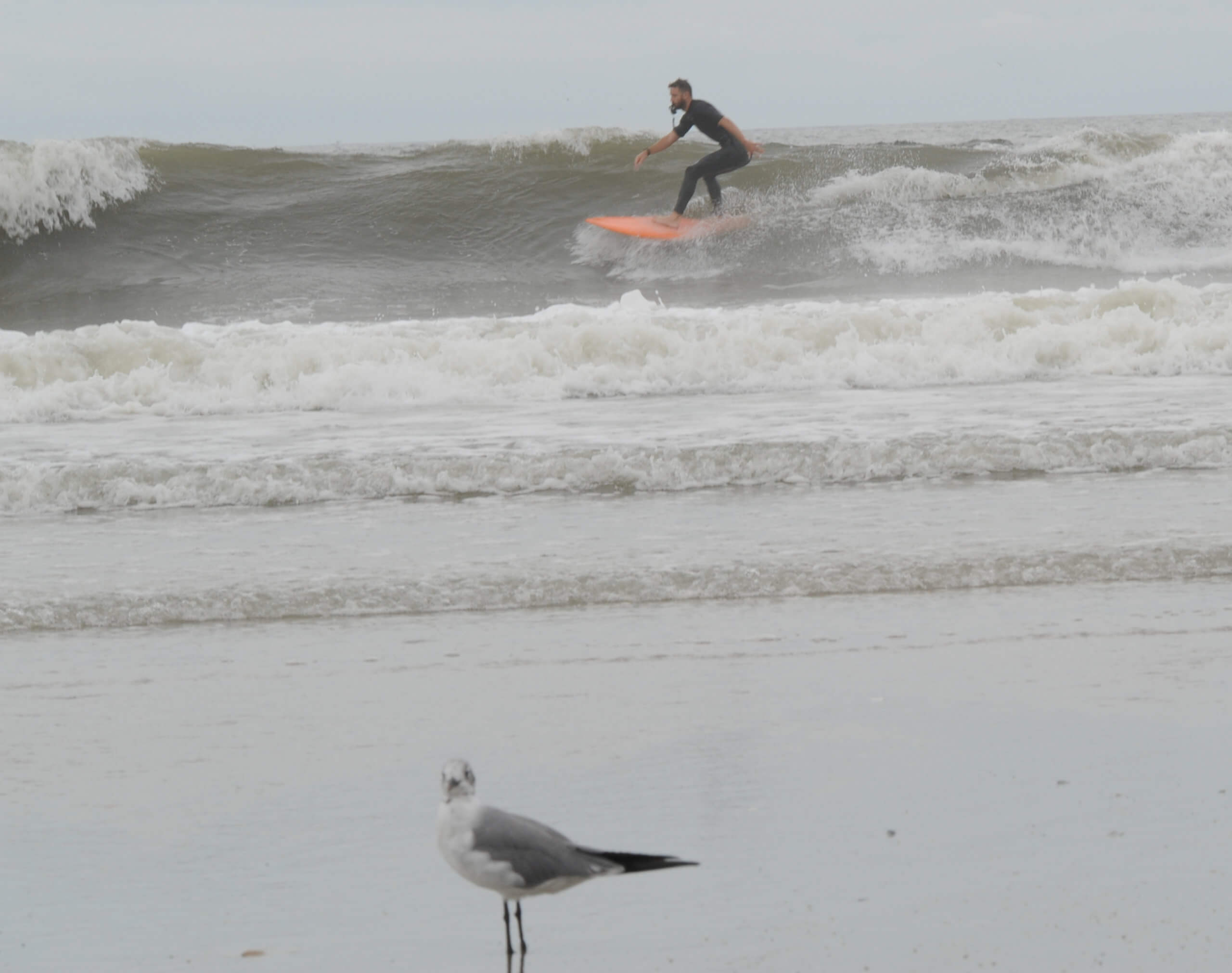
Henri’s rains could begin falling across New York City as early as Saturday evening, according to the National Weather Service. The wind will also pick up; the Five Boroughs will likely experience tropical storm-force winds of at least 39 mph for much of the day Sunday, with higher gusts possible.
Parts of the city can expect to see between 2 and 4 inches of rain, with higher amounts possible in isolated spots. As with any tropical system, Henri has the potential for spawning strong thunderstorms and even isolated tornadoes.
Some New York City areas could suffer power outages due to the storm. Con Edison says they are monitoring the storm and have 1,500 mutual aid workers on standby ready to respond to power outages beginning Sunday morning.
Areas with overhead power lines may be particularly vulnerable to power outages due to high winds toppling lines and tree limbs. If you see downed power lines, do not touch them; call Con Edison at 800-75-CONED. You can also use that same number to report power outages.
“The priority for restoration will be critical customer facilities that have an impact on the public, such as mass transit, hospitals, police and fire stations, and sewage and water-pumping stations,” according to a Con Edison statement. “Crews will then prioritize repairs that will provide power to the largest numbers of customers as quickly as possible, then move on to restore smaller groups and individual customers.”
Riding out the storm
The city’s Emergency Management Department advises residents to have batteries, flashlights and a hand-powered radio in case of an outage, and turn all refrigerators and freezers to a lower setting. If you have a generator, do not use it inside the home.
Call 911 if you or someone you love has a disability that requires life-sustaining equipment, and suffers a power outage.
The Emergency Management Department also offers these general hurricane safety tips:
• If you live in a flood-prone area, keep materials, such as sandbags, plywood, plastic sheeting, and lumber on hand to help protect your home.
• If you have a disability or access or functional need, make sure your plan addresses how your needs may affect your ability to evacuate, shelter in place, or communicate with emergency workers. Arrange help from family, friends, or service providers if you will need assistance.
• When outside, avoid walking and driving through flooded areas. As few as six inches of moving water can knock a person over. Six inches of water will reach the bottom of most passenger cars, causing loss of control and possible stalling. One or two feet of water can carry away a vehicle.
• Stay out of any building if it is surrounded by floodwaters.
• If you see downed electrical wires, do not go near them. Never attempt to move or touch them with any object. Be mindful that tree limbs, leaves, or water can cover downed wires from view. Always stay away from downed power lines because they could be live.
• Report downed wires immediately. If a power line falls on your car while you are in it, stay inside the vehicle and wait for emergency personnel.
Read more: NYC Gears Up for Influx of Travelers Ahead of Solar Eclipse


