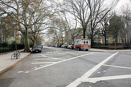
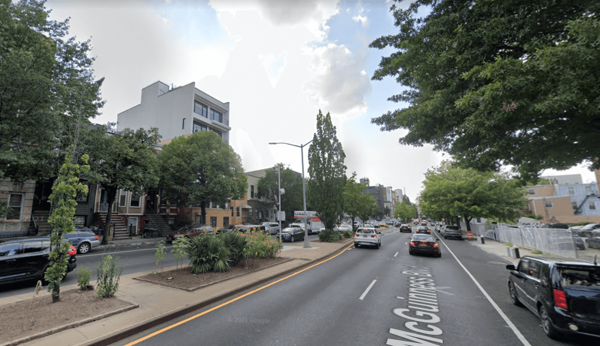
The city’s Department of Transportation last week unveiled their preliminary designs for the start of the redesign of McGuinness Boulevard to mixed reviews as the community and city officials campaign to make the dangerous roadway safer.
At a meeting of Community Board 1’s Transportation Committee on June 30, DOT presented their draft proposal for the “in-house” redesign of McGuinness — not the full $39 million redesign funded by then-Mayor Bill de Blasio last year after elementary school teacher Matthew Jensen was killed in a hit-and-run while crossing the street.
“These are projects that we can work on very quickly, compared to the capital process, which can take ten years or more at times,” said DOT engineer Zach Wyche.
The current proposal would not be using the $39 million set aside for the Capital Project, Wyche explained, but the changes DOT makes now will influence the design of the capital project in the future.
“In-house” projects, like the one DOT proposed for McGuinness Boulevard, typically make use of things like paint and bollards, which can be installed and changed relatively easily and cheaply — whereas the full capital redesign will include permanent changes to the structure of the road and sidewalks.
Wyche presented three possible designs for McGuinness, each built using feedback from multiple virtual public outreach sessions, in-person canvassing, and meetings with local businesses and the Make McGuinness Safe Coalition.
“From a lot of people we heard that it feels like a neighborhood boundary, that McGuinness feels unsafe, that a lot of people have seen or experienced close calls or been in crashes themselves,” Wyche said.
McGuinness is crowded with vehicles during the day, with more than 1,3000 vehicles traveling in each direction every hour in the morning, Wyche said, but at night, the wide and empty street is a hotbed for speeding. Both cyclists and pedestrians said they feel unsafe in close proximity to traffic.
Potential Design A
DOT’s first option would preserve all four vehicle travel lanes on McGuinness during daylight hours — from 7 a.m. to 7 p.m. — by prohibiting parking on the street during that time and replacing the curbside parking lanes on both sides of the street with dedicated bicycle lanes.
After 7 p.m., the outermost traffic lanes on both the northbound and southbound sides would become parking lanes — narrowing the roadway to curtail speeding drivers and creating a barrier between cars and the bike lane. The department would work with local businesses to create dedicated truck loading zones on adjacent side streets.
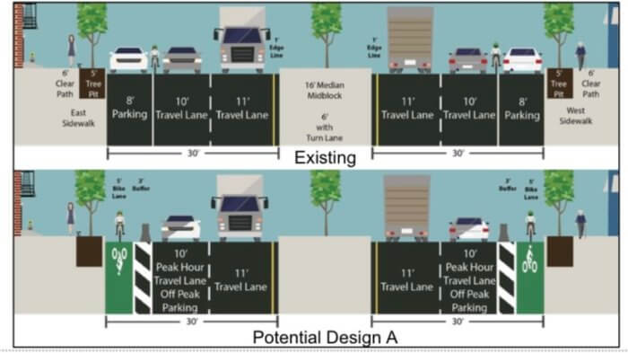
“By leaving the same amount of travel lanes, we would be able to change the signal timing a lot,” Wyche explained. “We would give more people a lot more time to cross, a lot less time that they’d have to wait to cross the street, and it would shift the street from feeling like it’s a highway to it’s just flowing for most of the day.”
Design A is the only one that could be implemented right away, without any further study by DOT, since it most closely resembles the street’s existing layout.
Potential Design B
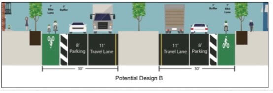
The second potential design would remove vehicle travel lane on each side of the boulevard, making way for a parking-protected bicycle lane along the curb, and one 11-foot-wide vehicle lane.
While most signal times would stay the same, new pedestrian islands at each intersection would reduce the average crosswalk length by 23%, Wyche said, and most parking and truck loading zones would be preserved.
“Although, while it would keep the parking and loading space, in a situation where someone would try to load, or someone breaks down in the one travel lane that’s remaining, it would mean that the street would be at a standstill if someone stopped,” he said.
Potential Design C
The final option would remove one vehicle travel lane and the parking lane from the southbound side of McGuinness Boulevard, leaving the northbound side more or less untouched, with both vehicle lanes and the curbside parking lane intact.
On the south side, DOT would install an 11-foot-wide, two-way bicycle lane separated from the single vehicle lane by a wide buffer zone. The buffer zone would be wide enough for emergency vehicles to pass through if the vehicle lane was backed up and gives disabled vehicles enough space to pull over and out of the way.
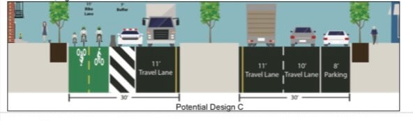
“One of the disadvantages that is maybe a little bit more complex than some people think about is that by adding a bicycle lane going pretty much the wrong way up the street on the southbound side, we’d have to do a lot more complex signal timing,” Wyche said.
That would likely mean long pedestrian wait times would persist.
The department would need more time to study traffic patterns before they could implement designs B or C, the engineer added.
Any of the three designs would be accompanied by additional changes — new pedestrian islands at particularly wide and dangerous intersections; the removal of a traffic lane on the southbound side between Enger and Meeker avenues to make space for cyclists and pedestrians; a redesign of the Freeman Street intersection; and banning “lightly used” left turns at certain intersections including Nassau and Driggs avenues.
The response
The presentation was slammed by local Councilmember Lincoln Restler, who said the proposals weren’t enough — and that he, along with Assemblymember Emily Gallagher and representatives of state senators Julia Salazar and Brian Kavanagh, have repeatedly met with DOT in recent weeks, urging the department to consider removing a vehicle traffic lane.
“I’m really disappointed that after hearing so clearly from the elected officials in the community, from many thousands of neighborhood residents … that still DOT came forward with this presentation tonight,” Restler said. “I really hope that summer can be a time to go back to the drawing board and pursue other alternative options and keep looking at how we can actually finally make McGuinness safe.”
Restler’s concerns were echoed by Bronwyn Breitner, a member of CB1’s transportation committee and a coordinator for the Make McGuinness Safe Coalition.
“I have to say that I find what you presented as Plan A to be the number one concern from the community in light of all these deaths and injuries,” Breitner said. “Let’s just talk about injuries for a second … if you break it down, somebody is injured in McGuinness Boulevard every month.”
The majority of crashes happen during the day, Breitner continued, so reducing the number of lanes at night would not address the main issue on McGuinness, and she worried that Plan A would just be forcing pedestrians to cross six lanes of traffic — the four vehicle lanes plus the two curbside bike lanes.
Karen Nieves, another committee member, said she was worried about the local traffic impacts of restricting left turns, particularly for trucks — many residents complain about trucks crowding narrow local streets, she said.
Those complaints have given DOT pause in considering whether or not to restrict those left turns, said Nick Carey, lead engineer of the department’s bicycle unit.
“It’s not that our priority for McGuinness Boulevard is to push traffic through, and all the negatives that come with that, but we are concerned about what some of the spillover impacts would be, and that’s why we want to study it a little bit more,” Carey said.
Removing car traffic lanes could result in “significant congestion” on McGuinness as well as increased traffic on Manhattan Avenue, according to DOT studies.
Dozens of speakers took the opportunity to praise or criticize the proposals — more than one local called McGuinness Boulevard “a nightmare,” and said it prioritizes the needs of those looking to cut through the neighborhood, rather than Greenpoint residents.
Some said they wanted to preserve parking and truck access for residents and local businesses, urging DOT not to remove daytime parking.
Wyche emphasized that the department was presenting the three plans “equally,” and that no decisions have yet been made for the design.
DOT will spend the summer meeting with elected officials and community stakeholders as they refine their plans, and will likely return to the community board in the fall. Some in-house changes will be made in 2022, and, once a redesign plan has been confirmed, the full changes will be implemented next year.
The heated hearing came just days after the Make McGuinness Safe Coalition sent the agency a petition signed by more than 2,500 local residents in support of dramatic changes to the streetscape.
“We need this death trap to be fixed urgently,” Breitner told Brooklyn Paper.