
By Ronda Kaysen
A major hurricane could hit the Northeast as early as this summer, weather experts said Monday. And Lower Manhattan — including the new World Trade Center — risks severe flooding in coming years because of rising sea levels, Columbia scientists warn.
“The Northeast is staring down the barrel of a gun,” said Joe Bastardi, chief forecaster of the AccuWeather.com Hurricane Center, a nonprofit weather firm, in a prepared statement. “The likelihood of a major hurricane making landfall in the Northeast is not a question of if but when.”
As sea levels rise over the course of this century, parts of the new World Trade Center along with Battery Park City, the South Street Seaport, Battery Park and the Financial District are at risk of 10-foot storm surges when powerful Northeasters or hurricanes make landfall, Columbia scientists predict. Flooding could potentially devastate the city’s subways, tunnels, beaches, wetlands, airports and roads.
“You could get more frequent episodes of flooding,” said Dr. Vivien Gornitz, a geologist and special research scientist for NASA Goddard Institute for Space Studies and Columbia University. “The city needs to be aware of the problem.”
Although New York will not become a new Venice, with gondoliers replacing subway tunnels, periodic storms could inundate much of Lower Manhattan and other large areas including parts of Staten Island, Brooklyn, Queens and Long Island.
But Venice is not necessarily a bad model to follow, said Gornitz, noting that the city installs boardwalks above the normal sidewalks and people wear hip-high boots during storms.
A map of Lower Manhattan created by Columbia scientists in 2000 shows risks of 10-ft. flooding during storms. Along the East River, the 10-ft. flood zone extends to Water St., to the South Street Seaport, inland near Tompkins Square Park and north to Bellevue Medical Center. The west side of Manhattan is at risk for 10-ft. storm surges from the Battery to 23rd St. and from the Hudson River to east of West St., with all of Battery Park City and parts of the new Trade Center site at risk for 10-foot floods.
“New York is not very high up, to say the least. We’re a tiny island, we’re just as vulnerable as somebody out in the Pacific,” said Wendy Brawer, founding director of Green Map, an organization that produces environmental maps for cities. Green Map’s latest New York City map, which was published last month, illustrates the changing flood zones in the city. “There has been a blinking red light for a long time and we have not been facing it. It doesn’t take but one storm for all of us to have this wakeup call that we’re totally unprepared for.”
Fierce storms with severe flooding are not new to New York. In 1960, Hurricane Donna inundated Manhattan with 10-foot high tides. Water was hip deep at the corner of Vesey and West Sts. where the W.T.C. was later built. And in 1992, a Northeaster ripped through Manhattan, shutting down all of the city’s 25 subway lines, the F.D.R. Drive and La Guardia Airport. Powerful storms like the 1992 Northeaster may occur as frequently as once every four years by 2080, researchers say.
“It looks like it’s inevitable that there’s going to be some change, we’re not going to be caught by surprise,” said Dr. Roberta Balstad, director of the Center for International Earth Science Information Network at Columbia. “On the other hand, if we’re complacent, we will be caught by surprise. Because we’re talking about long time frames, it means that the city has to be thinking in terms of the long haul. It needs to be thinking about its infrastructure.”
The W.T.C. memorial, Gornitz said, could easily flood “unless they have special flood gates to seal it off,” she said.
The Lower Manhattan Development Corp., the agency that is overseeing the design of the memorial, believes the memorial will not get flooded. “The designs would be resistant to those types of flooding dangers,” said Victor Gallo, senior advisor and counsel for environmental and regulatory affairs for the L.M.D.C. “We’re not concerned that we’re in a high hazard area.”
The rebuilding process has been subject to an Environmental Impact Statement, which involves addressing issues of flooding and other environmental concerns. As part of that process, the public is able to weigh in and voice concerns that the sea level is rising, said Gallo.
The Port Authority of New York and New Jersey owns the World Trade Center property and reinforced the slurry wall after 9/11. It also plans to rebuild the eastern bathtub to make way for new towers at the site and is responsible for the ferry terminal in Battery Park City. In 1967, when the Trade Center was built, the soil there was saturated with water. A three-foot thick slurry wall created a bathtub to keep the Hudson out.
“The entire site is being designed to New York City building codes and FEMA [Federal Emergency Management Agency] codes for a 100-year flood,” Steve Coleman, a Port spokesperson, said in reference to the worst floods expected in a century.
He did not say what the specific protections are or if they would hold up if the Columbia scientists are right about rising sea levels changing the 100-year storm model.
And that model is changing, say many scientists. Sea levels have been rising along the East Coast since the end of the last glacial period, but models show the rate is accelerating. Currently, sea levels in New York City are rising at 0.11 inches a year, which is faster than the global rate, but still relatively manageable, according to Gornitz. But Columbia models project that the rate is accelerating and in 20 years, the sea levels could rise by as much as 11.7 inches and by the 2080s, they could rise by as much as 42.5 inches. Precipitation is also increasing. It has increased by an inch since 1900, but by the 2020s it could increase by 9 percent and by the 2080s, it could increase by 30 percent.
“All of the models are tending toward an upward trend and at an accelerated rate than what we’ve seen in the past,” said Gornitz. “They vary on how much and how soon.”
Gornitz said the typical model of using the past 100 years to help estimate the worst floods in the coming century may no longer work with the accelerating rate. By 2080, a storm that is now considered a storm of the century may occur every four years.
The Environmental Protection Agency however, disputes the potential rise in sea level, saying it will rise by as much as 12 inches in the next 50 years with “a small effect on Manhattan,” including flood risk.
On Thursday, three State Assemblymembers will release a study deeming New York City’s hurricane evacuation plan inadequate. The plan finds fault with emergency shelters, nursing home evacuations, transportation and educational programs.
“It simply can’t function,” Assemblymember Richard Brodsky said in a telephone interview. “We are looking at a situation not much different from what happened in New Orleans.”
Gornitz was reluctant to compare New York City to New Orleans, noting that much of New Orleans is below sea level and sinking rapidly, problems that do not affect New York. New York could prepare for larger storms by raising the seawalls and creating tidal bridges and dykes to deal with the increased risk of floods as sea levels rise.
The Battery Park City Authority is developing a capital plan to renovate its existing seawall, which runs the entire length of the neighborhood. The wall has never been renovated since it was built in 1960s and it will cost $30 million to improve it this summer as part of a routine maintenance plan. But the authority has no plans to raise the seawall.
“We have not developed a specific plan to deal with a rise in sea levels,” said James Cavanaugh, president and C.E.O. of the authority. “Rising sea levels clearly needs to be an issue for New York as a whole. It’s not likely that we’d march ahead by ourselves.”
Some Battery Park City residents are already thinking about the path that lies ahead. At the Extreme Weather Fair at I.S. 89 last week, eighth graders produced a video titled, “What if Lower Manhattan Floods?”, that discussed the possibility of flooding in their neighborhood because of global warming.
With reporting by Chad Smith
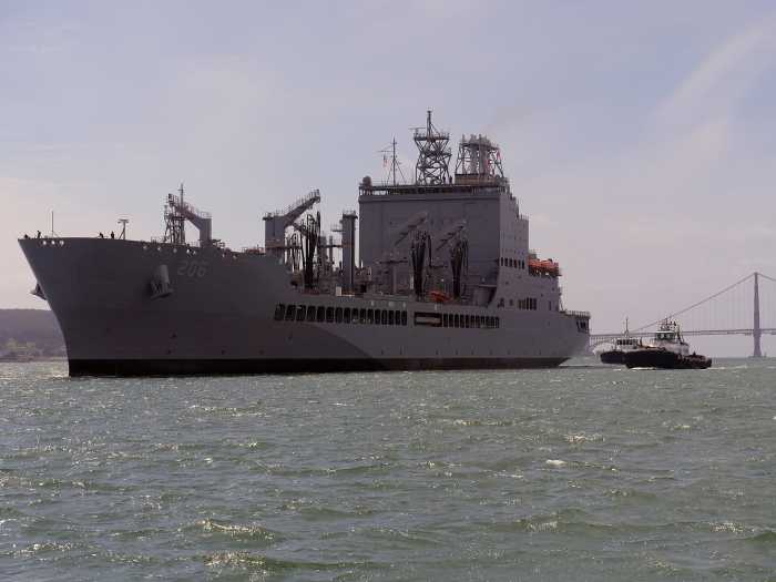
Battery Park’s harbor memorial for sailors lost at sea would likely be underwater after big storms if Columbia University scientists are right.
WWW Downtown Express