BY TERESE LOEB KREUZER | FEMA (the Federal Emergency Management Agency) has just released a preliminary flood risk map for New York City showing the vulnerability of the Manhattan waterfront.
The perimeter of the west side of Manhattan along the Hudson River is in Flood Zone V according to the Advisory Base Flood Elevations (ABFE) shown in the new FEMA map.
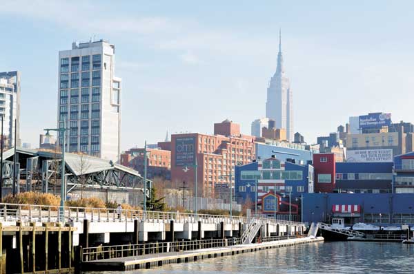
All of Chelsea Piers would be in this flood zone, subject to the most serious flooding.
Large sections of the western part of Chelsea are designated as being in Flood Zone A, where they have a lesser, though still substantial, risk of flooding. West Street and 11th and 12th Avenues are in this flood zone. Just south of 23rd Street, Flood Zone A reaches almost as far east as 9th Avenue, where many Chelsea art galleries are located.
Frank Gehry’s IAC building is in Zone A. So is Jean Nouvel’s building at 100 11th Avenue. Between 30th Street and 33rd Street, Zone A reaches to 10th Avenue.
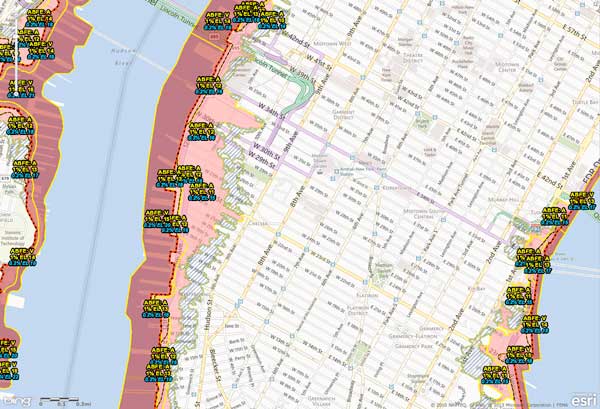
In the Zone: FEMA’s Flood Risk Map puts West Chelsea in Zones A and V.
Just north of there, the Jacob Javits Convention Center would be partially flooded in another major storm, according to the Advisory map. So would the entrance to the Lincoln Tunnel.
Flood Insurance Rate Maps (FIRM) for many communities in New York and New Jersey were last drawn up 30 years ago based on then-current information about the probability of flooding. The newly released maps are preliminary as FEMA sorts through an extensive amount of new data. The new maps are based on studies that were already under way before Superstorm Sandy.
Until finalized maps are available, Advisory Base Flood Elevations can help communities, home and apartment owners and businesses better understand flood risks so that buildings can be modified and constructed to reflect the new reality. Buildings with reduced flood risk because they have been elevated or otherwise modified will have significantly lower insurance premiums.
The maps show the probability of a flood in any given year. Advisory Zone V could be flooded by high velocity, breaking waves of three feet or more. Buildings in this zone must be elevated over an open foundation so that waves can break under them.
In Zone A, flooding from storm surges can be expected. The lowest floors of buildings in this zone should be used for parking and building access, with utilities raised above the base floor elevation or otherwise floodproofed.
Every flood zone on the FEMA maps has a Base Flood Elevation (BFE) assigned to it which identifies the level to which floodproofing is required by FEMA guidelines. For each location, the guidelines describe a 1 percent chance of water rising above the coastal water surface elevation in any given year, and a 0.2 percent chance. The elevations that would be protective in the event of a flood are expressed in feet.
Between West 18th and West 22nd Streets, for instance, in Flood Zone V, structures would have to be elevated by 15 to 20 feet above sea level to be safe from anticipated flooding. In Flood Zone A, they would have to be 12 to 16 feet above sea level. The protective elevations vary from building to building and block to block.
Flood damage is not covered by most homeowners’ insurance policies, however the federal government has set up a National Flood Insurance Program (NFIP), which is available from private insurers, but which the federal government backs and supervises. This insurance can protect homes, businesses and belongings. A home can be insured with NFIP for up to $250,000 for the building. Renters and homeowners can take out up to $100,000 worth of insurance on contents.
Up to a total of $1 million is available for non-residential buildings. This coverage would consist of $500,000 for the building and $500,000 for its contents.
There is usually a 30-day waiting period before coverage goes into effect.
Regardless of flood risk, most people can buy NFIP coverage if they live in a community that participates in the program. All five boroughs of New York City participate. Policies are available to homeowners, condo owners, apartment owners, renters and business owners.
Adopting standards based on Advisory information will not change current flood insurance rates within a community. Flood insurance policies are rated using the zones and flood elevations on the current effective FIRM. These rates will not change until local governments have had a chance to review, comment on and adopt the revised base flood elevations.
However, according to Howard Slatkin, director of sustainability for the New York City Department of City Planning, “Premiums for many properties in New York City are expected to increase substantially until they reach market rate. Buildings that once had preferential rates because they were built before FEMA’s current flood elevation maps and were grandfathered in, will no longer be eligible for those rates. So if you’re constructing a building today, it’s important to use [the new] information in order to prevent being hit by increased flood insurance rates.”
To see the new FEMA flood maps and to check on the status of any given building or neighborhood, go to region2coastal.com/sandy/abfe/.
For more information about the NFIP and flood insurance, call 800-427-4661 or go to floodsmart.gov.
This is an amended version of an article which posted February 25, 2013, on the website of our sister publication, NYC Reconnects (nycreconnects.com).
