By Ronda Kaysen
After half a century of floating plans for the East River waterfront, it looks like the Bloomberg administration may have finally sunk anchor with Community Boards 1 and 3. The Department of City Planning unveiled detailed plans to redevelop the waterfront at two recent community board meetings, to the delight of many board members. The designs include a refurbished esplanade, grass areas, glass-enclosed pavilion spaces for retail, rehearsals, performances and meetings — and even a sandy beach on the Lower East Side.
“I’m quite amazed at the plan — not only the substance but the process — and I’m very appreciative of the city,” said Victor Papa, a C.B. 1 member and director and president of Two Bridges Neighborhood Council, in a telephone interview. T.B.N.C. presented a petition with signatures from 1,100 local residents in support of the plan to City Planning at the March 10 C.B. 3 meeting. “The city has been quite honest in its attempts listen to the community,” Papa said. “They have gone out of their way to present these things to the community.”
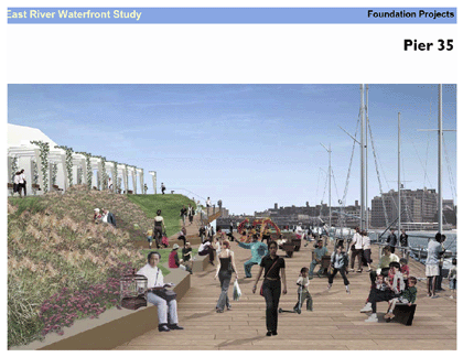
The plan, incorporating input from both community boards, includes significant changes to Piers 35 and 42.
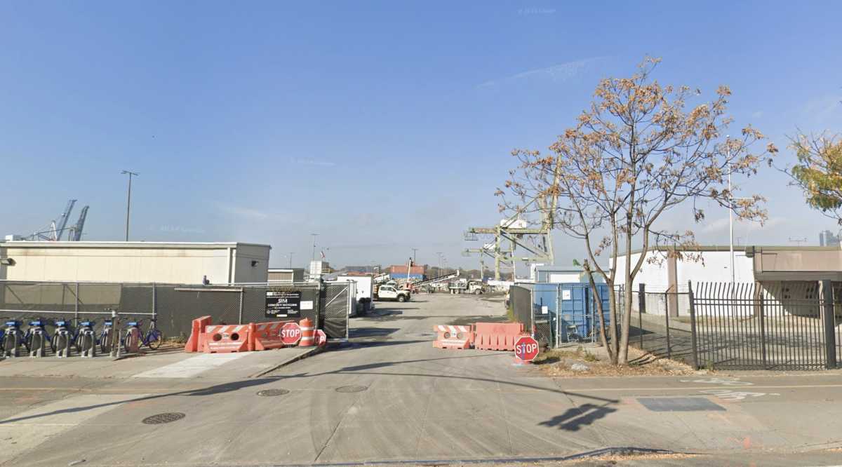
Pier 35, near Rutgers St., previously the Sanitation Department’s snow dumping ground, would be accessible to the community and transformed into a “community open space to get people out to the river,” said Michael Samuelian, director of Lower Manhattan special projects for City Planning, at a March 7 C.B. 1 meeting. The Sanitation building would be screened with new landscaping and a “viewing porch” would be incorporated alongside a new pier park for transient boats.
A bit to the north, the city plans to remove the empty shed at Pier 42, at the south end of East River Park, bringing the esplanade to the river’s edge. The reclaimed pier would be outfitted with grassy berms and a sandy beach, although a railing at the river’s edge would keep visitors from accessing the water.
Access to East River Park will be improved and the park itself would be upgraded with a link between the esplanade and the park, as well as landscaping that will create a visual and acoustic buffer to the F.D.R. Drive.
“This is a crucial plan to strengthen Lower Manhattan,” City Planning Commissioner Amanda Burden said at the C.B. 1 meeting. “The East River waterfront is one of the most essential waterfronts in the city.”
Some residents, however, were skeptical that the new waterfront access at Pier 42 will be access enough. “I was very disappointed that in the plan there was no mention made of the little beach we have under the Brooklyn Bridge and no way to create public access to it,” said Christine Datz-Romero, director of the Lower East Side Ecology Center, referring to a small beachfront beneath the Brooklyn Bridge that is closed to the public. “The whole plan talks about bringing people to the waterfront…. It’s a missed opportunity not to explore [the beach access] further.”
One component of the plan — a reflecting pool on Peck Slip that will double as a mini ice-skating rink in the wintertime and was met with community skepticism when it was proposed last fall — does brings water into Manhattan.
“The idea of actually bringing water back into the island is compelling if we can make it work,” said Ken Smith at the C.B. 1 meeting of Ken Smith Landscape Architects, which has been working on the East River Waterfront project for nearly a year with Gregg Pasquarelli of ShoP Architects and Michael J. P. Davies of the Richard Rogers Partnership in London.
A watery pool on Peck Slip is no substitute for the East River itself. “As much as there was talk about revitalizing the waterfront, the plan is really more about having people looking out at the water, not having the water be a part of the community,” said Datz-Romero.
The design includes as many as 15 glass-enclosed pavilions under the F.D.R. Drive, which would be used for shops, community and cultural programs and recreation centers. In an effort to transform the highway viaduct into something other than an eyesore, the plans would include adding lighting and cladding.
The pavilions suffered the heaviest criticism from board members. “We have to be careful about what the pavilions are used for and that we don’t just put profit-making entities that are beyond the use and the reach of the community to enjoy,” said Lois Regan, chairperson of C.B. 3’s Waterfront Task Force, in a telephone interview. Regan hopes to see the pavilions used for cultural institutions and nonprofit organizations, as do other C.B. 3 members and residents.
The business plan for the pavilions would be developed with community input, Burden said at the C.B. 1 meeting. “We wouldn’t even think of going forward without a real understanding and consensus from the community,” she said.
Plans also include adding greenery and park benches at Rutgers, Catherine and Montgomery Slips as well as improving the medians at Pike and Allen Sts.
“We see this as a great opportunity,” said Samuelian, “a real gateway to the waterfront.”
Regan sees improving the slips as more than an opportunity to provide a “gateway to the waterfront.” She sees it as a way to bring security to the area. “We have to get that area safer,” she said. “We need improved lighting and we need crosswalks.”
In a marked change from the October proposal, the residential towers proposed to sit atop the F.D.R. Drive are now gone from the renderings and the plans.
Perhaps the most dramatic change is to the Battery Maritime Building. The plan calls for moving the mouth of the Battery Park underpass ramp about 350 ft. north to Broad St. Moving the ramp away from the Maritime Building would create three-quarters of an acre of open plaza space — a scarce resource on Downtown’s east side.
City Planning has decided to seek separate transportation funding for the Maritime Building component of the project, although Rachaele Raynoff, a Planning spokesperson, declined to site specific funding sources.
Several C.B. 1 members had been concerned that too much money in the project’s first phase would be devoted to connecting the bike path with the West Side at the Battery Maritime Building rather than improving the East River esplanade itself.
Regan of C.B. 3 and Papa of T.B.N.C. and C.B. 1 hope to see the first phase of changes begin soon. “We want short-term things,” Papa said. “You have got to take the [chain-link] fence down. You have got to take the jersey barriers down. You have to put planters in.”
Before any further steps can be taken for the costly project, the city needs to procure funding. The riverfront 2-mile esplanade is alone expected to cost between $60 and $65 million. City Planning expects the Lower Manhattan Development Corporation to foot most of the $150 million bill for the East River Waterfront plan. The L.M.D.C., governor and mayor are planning to release a report at the end of the month outlining how the agency will spend its remaining $800 million.
