The New York City Council will soon vote on the last of the outgoing Adams administration’s major rezoning initiatives — the Jamaica Neighborhood Plan.
The plan includes a package of text and map amendments to the zoning resolution that the administration projects will create over 12,000 new homes, of which approximately 4,000 would be affordable; over 2,000,000 square feet of commercial and community facility uses; and more than 7,000 jobs in Jamaica, Queens. The plan also includes an Urban Development Action Area Project (UDAAP) Disposition that would redevelop and improve vacant, underutilized city-owned land with 100% income-restricted housing.
After two years of study, the plan began the Uniform Land Use Review Procedure (ULURP) process earlier this year with the advisory recommendations of the affected community boards and the borough president. Both community boards recommended disapproval of the plan, with many of the concerns cited involving parking. One board voted 1-35 against the plan, while the other voted 17-18 against it. Queens Borough President Donovan Richards gave a conditional favorable recommendation, but said he wanted the city to make additional affordable housing investments in the area. The plan was then approved in August by an 11-2 majority at the city planning commission.
Now the plan has reached the final stage required for approval through ULURP, which is the city council, where the primary decisionmakers will be the affected council members: speaker Adrienne Adams, Nantasha Williams, and Jim Gennaro. At the council’s zoning and franchises subcommittee hearing last month, community members and others raised concerns regarding sewer and stormwater infrastructure upgrades, groundwater flooding relief, open space and transit improvements, school capacity, support for cultural institutions, pathways to homeownership and protection for local businesses and faith-based organizations.
The plan’s zoning text amendment would expand the Special Downtown Jamaica District originally established in 2007, and apply Mandatory Inclusionary Housing and special regulations to support jobs, activate ground floors, facilitate streetscape improvements, open space, and a mix of uses, which would cover approximately 300 blocks. The plan has several components:
-Downtown Core
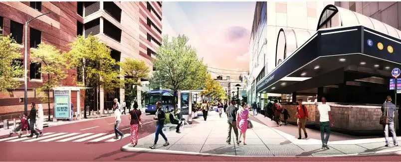
Within Jamaica’s “Downtown Core”, which runs from Jamaica Avenue to Archer Avenue, higher density commercial zoning districts would be mapped, which would allow an “FAR” or “floor area ratio” of 9.02 to 12.0 for residential and total use, 6.0 to 12.0 FAR for commercial use, and 7.5 to 10.0 FAR for community facility use. That means, for instance, if a property has a lot area of 10,000 square feet and its zoning district allows 10.0 FAR of residential use, then 100,000 square feet of residential floor area can be built on the property. The Downtown Core would allow “tower” development, with no maximum building height; building height would be constrained by the maximum FAR.
-North Core
North of downtown would be the “North Core,” which runs from Hillside Avenue to Jamaica Avenue, where FARs would be less than in Downtown: 6.0 to 7.2 for residential/total use, 3.4 for commercial use, and 5.0 to 6.5 for community facility use. Here, building height would be limited to 145 feet, and a portion would be zoned as a residence district, meaning it would only allow residential and community facility uses, but not commercial uses.
-Southern Corridors
South of downtown, along the plan’s “Southern Corridors,” which covers major blocks including Sutphin Boulevard, Guy Brewer Boulevard and Merrick Boulevard, primarily residence districts would be mapped, allowing 5.01 to 7.2 FAR for residential/total use and 4.0 to 6.5 FAR for community facility use. These districts would have a maximum building height of 115 feet to 145 feet.
-South Core
The “South Core,” which covers the area directly south of Jamaica Center and includes the Archer Avenue bus terminal, would be mapped with mixed-use districts allowing light industrial/manufacturing use, along with residential, commercial, and community facility uses. The permitted FARs for all uses would range from 4.0 to 12.0 FAR. Building height would vary as well, with the lowest density district capping building height at 125 feet, while the highest density district would permit tower development with no maximum building height.
-Jamaica Industrial Business Zone
Within the existing Jamaica Industrial Business Zone, in the eastern portion of the study area, in order to support industrial growth and job creation, existing manufacturing districts would be replaced with manufacturing districts allowing higher density and a greater range of uses, with FARs of 3.0 to 4.0 for manufacturing/total use and for certain community facilities, with 1.0 to 3.0 FAR for commercial use (new residential use would continue to be prohibited within these manufacturing zones). Building height would be limited to 95 feet to 125 feet.
As the Jamaica Neighborhood Plan heads to a final vote by the City Council, we can expect negotiations between the Council and the Administration regarding the concerns raised and for commitments to infrastructure improvements and other investments into the community in order to support the added density the plan would facilitate. The outcome of these negotiations will determine the future of Jamaica, which could be dramatically reshaped by this transformative plan.
Dan Egers, a shareholder of Greenberg Traurig, focuses his practice on New York City land use and planning. The views expressed are his own.
Ed Wallace, co-chair of the New York office of Greenberg Traurig, served as the last Manhattan city councilmember at large and chief of staff to the City Council president. He has represented Columbia, Fordham and NYU in obtaining land use approvals. He is counsel to the Citizens Budget Commission.
