By Albert Amateau
While the Astor Place Task Force ponders the pros and cons of the city Department of Transportation’s proposal to close a part of Astor Pl. to auto traffic and make it a pedestrian way, Christabel Gough, a task force member and preservationist, went to the history books to make her point.
Gough, secretary of the Society for the Architecture of the City, believes altering a part of the short two-block street violates historic principles as well as urban aesthetics.
“Astor Pl. along with Stuyvesant St. predate the city grid plan and they’re very old. I don’t think any of it should be closed despite what some traffic engineer calls an improvement,” Gough said last week. Stuyvesant St., like Astor Pl., is a two-block diagonal street northeast of Astor Pl.
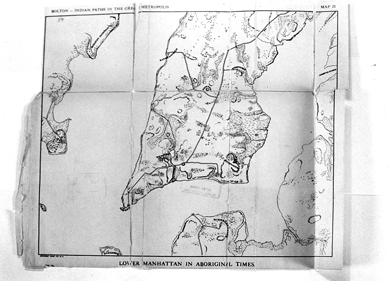
Citing a 1922 history by Reginald Pelham Bolton of Native American settlements in Manhattan, Gough said Astor Pl. is the remnant of an Indian trail that connected settlements on the east side of Lower Manhattan to Sapokanican, the Hudson River trading post at 14th St.
Indian trails became Dutch wagon roads, which in turn became Colonial post-roads and then city streets.
The Indian trail that started near the Battery ran up what is now Broadway to just south of the present City Hall at Park Row and then up to Chatham Sq. and up Bowery.
The prehistoric trail ran from what is now Bowery to Astor Pl. and curved west across the island, traversing the now subterranean Minetta Creek near what is now Washington Sq. Turning north, the road became what is now Greenwich Ave., and then turned west again to the river trading post, according to Gough’s research.
The park at the end of 14th St. at the West Side Highway, built by the state Department of Transportation, is named Sapokanican Park in honor of the trading post that was near the site before the Europeans came to the New World.
The path that eventually became Astor Pl. was shown in a 1639 map; the end of the road near the Bowery was known as the Gerritsen Wagon Way after the owner of a farm that it bordered. “Nearby were the land grants made by the Dutch to free black landowners,” Gough noted.
The road and its extension along the present Greenwich Ave. was surveyed in 1707 and identified as one of the four main highways on Manhattan. In 1768, it was surveyed again and renamed Art St. Beginning with the 1811 grid plan, the high points and low points along the way were leveled. The Zantberg (Sand Hill) near Washington Sq. disappeared. Art St. was closed between Sixth Ave. and Broadway in 1825 because it interrupted the symmetry of Washington Sq.
Greenwich Ave. was know for several years as Monument Road because it led to an obelisk erected around 1760 near the present-day 14th St. at Eighth Ave. in memory of General Wolfe, the English general who died at the Battle of Montreal during the French and Indian War.
But the east end of Art St. between Broadway and Bowery became an important center when the new Lafayette Pl. and Eighth St. were built around 1836. The city took title and named the triangle Astor Pl. after John Jacob Astor, who had acquired the land in 1803.
New buildings, like the Astor Pl. Opera House and the Eighth St. Presbyterian Church were erected on the triangle. “The remaining blocks of Art St. were re-named Astor Pl. in 1840, so that Astor Pl. finally became both the open space now the site of Tony Rosenthal’s giant steel cube, ‘The Alamo,’ and the former Art St. from Broadway to Third Ave.,” Gough said.
Astor Pl. was the site in 1849 of a deadly riot between fans of two rival Shakespearean actors, one British and the other American. Troops responded and when it was over, 23 men were dead and more than 100 injured.
“Like streets in the West Village or the Wall St. area, Stuyvesant St. and Astor Pl. are reminders of the earlier history of New York,” said Gough. She went on to recall that when Cooper Union put up its 1959 Engineering Building, it received permission to take over a portion of the Astor Pl.-Stuyvesant St. roadbed for academic use associated with the building. “The land is now devoted to a Starbucks,” Gough observed. “That was before the enactment of the Landmarks Law in 1965, before the designation of the St. Mark’s Historic District in 1969 and before the initiation of the New York City Environmental Quality Review executive order in 1977,” she added.
Gough recalled that as part of the Cooper Union general large-scale development plan zoning of 2002, “there was a commitment to leave the former roadbed of Stuyvesant St. partly open to preserve the view down Astor Pl.” She added, “Astor Pl. itself should also remain open — it’s part of history and should not be obliterated for what is being called ‘street improvement.’ ”


